
|
|

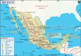
Total area - 1,964,375 sq km
Land area - 1,943,945 sq km
Water area - 20,430 sq km
Size comparative to U.S. territory - A little less than triple the size of Texas
List all countries which share a border (if island include body(ies) of water bordered) - Belize 276 km, Guatemala 958 km, US 3,155 km
Total distance of all land boundaries - 4,389 km
Total distance of coastline - 9,330 km
Description of climate - “varies from tropical to desert”
Description of Terrain - “high, rugged mountains; low coastal plains; high plateaus; desert”
Point of lowest elevation - Laguna Salada -10 m
Point of highest elevation - Volcan Pico de Orizaba 5,675 m
All information from cia.gov.

|

|
Population
Population (Mid-2012)
123,166,749 (July 2016 est.)
Density (people per sq. km)
62.7 people / sq. km
Net Migration Rate (# per 1000 people)
-1.7 migrant(s)/1,000 population (2016 est.)
Birth Rate (# per 1000 people)
18.5 births/1,000 population (2016 est.)
Death Rate (# per 1000 people)
5.3 deaths/1,000 population (2016 est.)
Rate of Natural Increase
13.2/1.32%
Population Growth Rate
1.15% (2016 est.)
Infant Mortality Rate (# of deaths per 1000 live births)
11.9 deaths/1,000 live births
Total Fertility Rate (average # of children per woman)
2.25 children born/woman (2016 est.)
Population Age <15 %
27.26% (male 17,167,636/female 16,402,301)
Population Ages 65+ %
6.93% (male 3,827,870/female 4,702,026) (2016 est.)
Dependency Rate (add together Population Age <15 % and Ages 65+ %)
34.19%
Life Expectancy at Birth (total)
75.9 years
Life Expectancy at Birth Females
78.8 years (2016 est.)
Life Expectancy at Birth Males
73.1 years
Primary School Completion Rate Females
105%
Primary School Completion Rate Males
104%
Secondary School Enrollment Net Females
69%
Secondary School Enrollment Net Males
66%
GNI PPP per capita in US$
12,580
Economically Active Females 15+
43%
Economically Active Males 15+
81%
Mobile Phone Subscribers (# per 100)
82
Motor Vehicles (# per 1000)
211
Undernourished Population
5%
Underweight Children Under Age 5
2.8%
HIV/AIDS Among People Ages 15-49
0.3%
Population Pyramids
1995

2010

2025

2050


Mexico is likely in Stage 3 of the DTM. As can be seen in the above picture, countries in Stage 3 have a declining CBR, low CDR, and a positive NIR. This is consistent with population trends in Mexico. In addition, Mexico is still a developing country. However, it has been somewhat developed. Therefore, Mexico is likely at Stage 3 of the DTM.

www.bit.ly/2d6f0c6
In this graph, life expectancy is on the y-axis, and overall access to sanitation is on the x-axis. I chose these two topics because Mexico underwent a large amount of development and population growth in the 20th century due to improved sanitation. Sanitation has historically had a large effect on life expectancy. Therefore, sanitation could be used to predict the life expectancy and overall development of a country. For these reasons, I chose to do a graph comparing sanitation and life expectancy for Mexico.
Sources: cia.gov, data.worldbank.org, prb.org
Culture
Ethnic Groups

Languages

Religion

Cultural Photos


The Amazing Race
The challenge begins at the Los Cabos Arch on the southern tip of the Cabo San Lucas and will end at Playa del Carmen.

- Challengers will arrive at the port of Tulum for the Riviera Maya
- They will obtain a canoe.
- They will use this canoe to travel up the Riviera Maya to the Playa del Carmen

The “check-in” point is the port at Playa del Carmen.
Cultural Journal Report
Art Scene Thrives on the Edges in Mexico City by Elisabeth Malkin
Date the article was written: March 11, 2016
Click here to read this article
The article details how Mexico City has become a destination for artists all over the world. Artists are drawn by the culture, atmosphere, and attitude of Mexico City. The movement has spread due to social media, and artists are adept at spreading information about the city. New artist-run exhibits are appearing all over the city. This movement will continue for an indefinite amount of time.
This article gives an interesting account of art in Mexico City. It describes some practical reasons as to why Mexico City is experiencing this cultural growth, which helps to reinforce its position. In addition, it helps to add to the excitement of the movement by giving quotes from people who live there. Finally, the article helps to explain the culture of Mexico City through various means, which adds to readers’ understanding and expectations of the city. For example, the article compares Mexico City and Detroit. This helps readers to develop an idea of what Mexico City’s culture is like. Because of this, the article provided a deep and compelling description of the artistic movement occurring in Mexico City.
The article describes how the artistic culture in Mexico City is changing. This has an important impact on Mexico City because it could bring tourists from around the globe and change the personality of the city. This may happen if the demographics in Mexico City change due to an influx of new tourists and immigrants. In addition, having art displays may affect the cultural landscape and lead to a more diverse visual style in the city. Finally, the increase in tourism and possibly immigration could lead to a more varied culture due to a mixing of various groups’ cultural heritages. Certainly, this artistic movement will have a critical impact on the future of Mexico City’s culture.
Politics
Conventional Long Form Name of country
United Mexican States
Capital City(ies) (some have multiple)
Mexico City (Ciudad de Mexico)
Type of Government
federal presidential republic
Date of Independence
16 September 1810 (declared); 27 September 1821 (recognized by Spain)
National Holiday(s): include date & event/celebration
Independence Day, 16 September (1810)
Chief of State (official public face of government)
President Enrique PENA NIETO (since 1 December 2012); note - the president is both chief of state and head of government
Picture of Chief of State/Head of Government

Description of Executive Branch/Powers
cabinet: Cabinet appointed by the president; note - appointment of attorney general, the head of the Bank of Mexico, and senior treasury officials require consent of the Senate
elections/appointments: president directly elected by simple majority popular vote for a single 6-year term; election last held on 1 July 2012 (next to be held in July 2018)
Description of Legislative Branch/Powers
bicameral National Congress or Congreso de la Union consists of the Senate or Camara de Senadores (128 seats; 96 members directly elected in multi-seat constituencies by simple majority vote and 32 directly elected in a single, nationwide constituency by proportional representation vote; members serve 6-year terms) and the Chamber of Deputies or Camara de Diputados (500 seats; 300 members directly elected in single-seat constituencies by simple majority vote and 200 directly elected in a single, nationwide constituency by proportional representation vote; members serve 3-year terms)
Description of Judicial Branch/Powers
highest court(s): Supreme Court of Justice or Suprema Corte de Justicia de la Nacion (consists of the chief justice and 11 justices and organized into civil, criminal, administrative, and labor panels) and the Electoral Tribunal of the Federal Judiciary (organized into the superior court, with 7 judges including the court president and 5 regional courts, each with 3 judges)
judge selection and term of office: Supreme Court justices nominated by the president of the republic and approved by two-thirds vote of the members present in the Senate; justices serve for life; Electoral Tribunal superior and regional court judges nominated by the Supreme Court and elected by two-thirds vote of members present in the Senate; superior court president elected from among its members to hold office for a 4-year term; other judges of the superior and regional courts serve staggered, 9-year terms
subordinate courts: federal level includes circuit, collegiate, and unitary courts; state and district level courts
Suffrage (who is allowed to vote)
18 years of age; universal and compulsory
Name of THEIR Ambassador to the U.S.
Ambassador Carlos Manuel SADA Solana (since 25 May 2016)
Location of THEIR embassy in the U.S.
1911 Pennsylvania Avenue NW, Washington, DC 20006
Location(s) of THEIR consulate(s) in the U.S. (just the name/s of city/ies is fine)
Atlanta, Austin, Boston, Chicago, Dallas, Denver, El Paso (TX), Houston, Laredo (TX), Los Angeles, Miami, New York, Nogales (AZ), Phoenix, Sacramento (CA), San Antonio (TX), San Diego, San Francisco, San Jose (CA), San Juan (Puerto Rico), Saint Paul (MN), Albuquerque (NM), Anchorage (AK), Boise (ID), Brownsville (TX), Calexico (CA), Del Rio (TX), Detroit, Douglas (AZ), Eagle Pass (TX), Fresno (CA), Indianapolis (IN), Kansas City (MO), Las Vegas (NV), Little Rock (AR), McAllen (TX), Minneapolis (MN), New Orleans, Omaha (NE), Orlando (FL), Oxnard (CA), Philadelphia, Portland (OR), Presidio (TX), Raleigh (NC), Salt Lake City, San Bernardino (CA), Santa Ana (CA), Seattle, Tucson (AZ), Yuma (AZ); note - Washington DC Consular Section is located in a separate building from the Mexican Embassy and has jurisdiction over DC, parts of Virginia, Maryland, and West Virginia
Name of U.S. Ambassador to THEM
Ambassador Roberta JACOBSON (since 20 June 2016)
Location of U.S. embassy THERE
Paseo de la Reforma 305, Colonia Cuauhtemoc, 06500 Mexico, Distrito Federal
Location(s) of U.S. consulate(s) THERE
Ciudad Juarez, Guadalajara, Hermosillo, Matamoros, Merida, Monterrey, Nogales, Nuevo Laredo, Tijuana
Name of THEIR representative to UN
Jorge Montaño
Picture of their flag

Description of the Symbolism of flag
three equal vertical bands of green (hoist side), white, and red; Mexico's coat of arms (an eagle with a snake in its beak perched on a cactus) is centered in the white band; green signifies hope, joy, and love; white represents peace and honesty; red stands for hardiness, bravery, strength, and valor; the coat of arms is derived from a legend that the wandering Aztec people were to settle at a location where they would see an eagle on a cactus eating a snake; the city they founded, Tenochtitlan, is now Mexico City
Video or audio of
their national anthem being played
https://www.youtube.com/watch?v=Q8T9g7memUk
National Symbol(s)
golden eagle; national colors: green, white, red
Descriptions
of International Disputes
abundant rainfall in recent years along much of the Mexico-US border region has ameliorated periodically strained water-sharing arrangements; the US has intensified security measures to monitor and control legal and illegal personnel, transport, and commodities across its border with Mexico; Mexico must deal with thousands of impoverished Guatemalans and other Central Americans who cross the porous border looking for work in Mexico and the US; Belize and Mexico are working to solve minor border demarcation discrepancies arising from inaccuracies in the 1898 border treaty
Quantity of refugees inside country AND
country(ies) of origin of refugees
N/A
Quantity of Internally Displaced Persons
287,000 (government's quashing of Zapatista uprising in 1994 in eastern Chiapas Region; drug cartel violence and government's military response since 2007; violence between and within indigenous groups) (2015)
Quantity of Stateless Persons
13 (2015)
Description of current human trafficking issues related to this country
N/A
Description of Illicit Drug trafficking/use
major drug-producing and transit nation; world's second largest opium poppy cultivator; opium poppy cultivation in 2009 rose 31% over 2008 to 19,500 hectares yielding a potential production of 50 metric tons of pure heroin, or 125 metric tons of "black tar" heroin, the dominant form of Mexican heroin in the western United States; marijuana cultivation increased 45% to 17,500 hectares in 2009; government conducts the largest independent illicit-crop eradication program in the world; continues as the primary transshipment country for US-bound cocaine from South America, with an estimated 95% of annual cocaine movements toward the US stopping in Mexico; major drug syndicates control the majority of drug trafficking throughout the country; producer and distributor of ecstasy; significant money-laundering center; major supplier of heroin and largest foreign supplier of marijuana and methamphetamine to the US market (2007)
Political Journal Report
Mexico warns Trump on tariffs: We'll respond 'immediately'
Author: Patrick Gillespie
Written on: 1/14/2017
Click here to read this article
This article discusses Mexico’s reaction to the president-elect’s proposed tariffs. Mexico warns that the tariffs could result in a global economic downturn. It also promised to retaliate against any harsh tariffs that Trump may try to impose. Both the U.S. and Mexico rely heavily on jobs from each other, so a dispute between the countries could be economically devastating. Despite Mexico’s threat of retaliation, it has not detailed how it plans to protest high tariffs.
The article fascinatingly shows how interconnected the U.S. and Mexico truly are. It seems basically impossible to stop the flow of business and jobs across the border as the president-elect proposes without doing serious economic harm. As a result, it is disturbing to see how relations between these two countries has deteriorated so rapidly. Mexico’s central has already unfortunately predicted a less robust economy after seeing the result of the 2016 American election. Overall, this article provides an interesting yet frightening take on the current state of U.S.-Mexico relations.
This article details how the Mexican government is dealing with economic threats from the American president-elect. It shows how reliant the U.S. and Mexico are on each other from an economic perspective. It also helps to show that the Mexican government plans to fight unfair treatment, contrary to what Mr. Trump hopes for. Due to the vital importance of a country’s economy, it can be inferred that how to respond to a possible high tariff from the U.S. is a major political issue in Mexico at this time. In addition, the article provides some insight into the political opinion of Mexicans toward the United States’ president-elect. In this way, the article provides a picture of both the Mexican economy and Mexican politics.
Agriculture
Total Area
1,964,375 sq km
Land Area
1,943,945 sq km
Water Area
20,430 sq km
Climate description
varies from tropical to desert
Terrain description
high, rugged mountains; low coastal plains; high plateaus; desert
Arable Land Use
11.8%
Permanent Crop Land Use
1.4%
Irrigated Land
65,000 sq km (2012)
Total Renewable Water Resources
457.2 cu km (2011)
Total Freshwater Withdrawal
80.4 cu km/yr
Per Person Freshwater Withdrawal
700.4 cu m/yr (2009)
Natural Hazards description
tsunamis along the Pacific coast, volcanoes and destructive earthquakes in the center and south, and hurricanes on the Pacific, Gulf of Mexico, and Caribbean coasts
volcanism: volcanic activity in the central-southern part of the country; the volcanoes in Baja California are mostly dormant; Colima (elev. 3,850 m), which erupted in 2010, is Mexico's most active volcano and is responsible for causing periodic evacuations of nearby villagers; it has been deemed a Decade Volcano by the International Association of Volcanology and Chemistry of the Earth's Interior, worthy of study due to its explosive history and close proximity to human populations; Popocatepetl (elev. 5,426 m) poses a threat to Mexico City; other historically active volcanoes include Barcena, Ceboruco, El Chichon, Michoacan-Guanajuato, Pico de Orizaba, San Martin, Socorro, and Tacana
Environmental Current Issues
scarcity of hazardous waste disposal facilities; rural to urban migration; natural freshwater resources scarce and polluted in north, inaccessible and poor quality in center and extreme southeast; raw sewage and industrial effluents polluting rivers in urban areas; deforestation; widespread erosion; desertification; deteriorating agricultural lands; serious air and water pollution in the national capital and urban centers along US-Mexico border; land subsidence in Valley of Mexico caused by groundwater depletion
note: the government considers the lack of clean water and deforestation national security issues
Total Labor Force
53.74 million (2016 est.)
% of Labor Force in Agriculture
13.4%
Agricultural Products description
corn, wheat, soybeans, rice, beans, cotton, coffee, fruit, tomatoes; beef, poultry, dairy products; wood products
Sources: cia.gov and indexmundi.com


A man is conducting tests on crops in Mexico.
Source
Source


Development and Industry
Population
127,017,000
GNI PPP Per Capita (US$)
$16,710
Women as % of Nonfarm Wage
Earners
40%
Women as % of Parliament
37%
CO2 Emissions Per Capita (metric tons)
1.0230126676
Death Due to Non-Communicable Diseases
78%
Births Attended by Skill Health Personnel (%)
93%
Democracy: CPIA Gender Equality Rating
No data
Economy: Big Mac Index
$2.66
Economy: Cash Surplus/Deficit (% of GDP)
-2.7% of GDP
Economy: Human Development Index
0.814
Economy: Technology Index
4.13
Education: Average Years of School for Adults
7.2
Education: Education Spending (as % of GDP)
5.3%
Education: Pupil-Teacher Ratio (elementary)
28.11
Education: Teachers as % of Labor Force
4.9%
Health: Expenditure Per Capita
424.3$
Health: Hospital Beds Per 1000
1 per 1,000 people
Health: Physicians Per 1000
1.5 per 1,000 people
Media: Televisions (total number)
25.6 million
Media: Per Capita Televisions (you compute this)
0.2015478243
% of GDP as Industry
33.1%
Total Labor Force
53.74 million
% of Labor Force in Industry
24.1%
Unemployment Rate
4.4%
Public Debt % of GDP
49.7% of GDP
Inflation Rate
2.7%
Industries
food and beverages, tobacco, chemicals, iron and steel, petroleum, mining, textiles, clothing, motor vehicles, consumer durables, tourism
Value of Exports
$359.3 billion
Export Commodities
manufactured goods, oil and oil products, silver, fruits, vegetables, coffee, cotton
Export Partners and %
US 81.1%
Value of Imports
$372.8 billion
Import Commodities
metalworking machines, steel mill products, agricultural machinery, electrical equipment, automobile parts for assembly and repair, aircraft, aircraft parts
Import Partners and %
US 47.3%, China 17.7%, Japan 4.4%
Currency Exchange Rate to $1.00
18.34
Electricity Production
286 billion kWh
Electricity Consumption
238 billion kWh
Electricity from Fossil Fuels
74.2% of total installed capacity
Electricity from Nuclear Fuels
2.5% of total installed capacity
Electricity from Hydroelectric Plants
18.7% of total installed capacity
Electricity from Renewable Sources
4.7% of total installed capacity
Refined Oil Production
1.258 million bbl/day
Refined Oil Consumption
2.007 million bbl/day
Natural Gas Production
44.37 billion cu m
Natural Gas Consumption
72.77 billion cu m
# of Land/Main Line Telephones
19,886,949
# of Cellular/Mobile Telephones
106.831 million
# of Internet Hosts
16.233 million
# of Internet Users
69.915 million
# of Airports (total)
1,714
# of Airports with Paved Runways
243
# of km of Roadways (total)
377,660 km
# of km of Roadways Paved
137,544 km
# km of Waterways
2,900 km
Location of Main Ports & Terminals
Altamira, Coatzacoalcos, Lazaro Cardenas, Manzanillo, Veracruz
Sources: prb.org, nationmaster.com, cia.gov, and indexmundi.com
Urban Geography
Identify the five largest cities within each country
- Ciudad de México
- Ecatepec
- Guadalajara
- Puebla
- Ciudad Juárez
Identify the population of the largest city
8,555,500
Use the “rank size rule” to identify the estimated size of each of the next four largest cities (city #2 is 1⁄2 the size of city #1, city #3 is 1/3 the size of city #1, city #4 is 1⁄4 the size of #1, city #5 is 1/5 the size of #1)
Ecatepec - 4277750
Guadalajara - 2851833
Puebla - 2138875
Ciudad Juárez - 1711100
Identify the actual populations of the 2nd, 3rd, 4th, & 5th largest cities
Ecatepec - 1,742,000
Guadalajara - 1,500,800
Puebla - 1,498,300
Ciudad Juárez - 1,398,400
Compose a well-developed paragraph defending to what extent the “rank size rule” is proven valid or invalid based upon the populations of this country’s five largest cities
The “rank size rule” fails to accurately predict the sizes of cities in Mexico. Ecatepec, Guadalajara, and Puebla all have much smaller populations than the rank size rule predicts. The rank size rule’s prediction for the population of Ciudad Juárez was somewhat close, but there was still a great disparity between the two numbers. In Mexico, Ciudad de México is a primate city. Because of these reasons, the rank size rule does not accurately describe population sizes in Mexico.
Population
127,017,000
Population Density
65 people per sq. km of land area
% Urban Population
79%
% Urban Population Living in Slums
11%
Average % Change in Urban Population
1.6%
% with Improved Urban Sanitation
85%
% with Improved Urban Water Supply
97%
Sources: prb.org, citypopulation.de, worldbank.org
